An independent guide to the culture, places and craft of Turkey
Landscapes
Why Cappadocia Looks Like That
Ash, then wind, then patience. A landscape taken apart from the top down.
By the ReaderLandscapes6 min readByzantine
01The Eruptions That Made the Ground
Everything in Cappadocia starts with volcanoes, and two of them in particular: Erciyes Dağı and Hasan Dağı, the pair of extinct stratovolcanoes that bracket the region east and west. Over millions of years, beginning roughly ten million years ago and continuing in episodes into geologically recent times, these mountains discharged enormous quantities of ash, pumice and pyroclastic material across the high Anatolian plateau. The material settled in deep layers — sometimes hundreds of metres thick — and compacted over time into a soft, pale rock called tuff. Not basalt, not granite, not the hard stone of most mountain landscapes: tuff, which is essentially welded ash, porous and workable and extraordinarily vulnerable to the forces that would later get to work on it.
The tuff is not uniform. Mixed into it, in irregular deposits and surface flows, is a harder volcanic material: basalt, which caps the landscape here and there in dark, resistant outcrops. That contrast — soft below, hard above — is the structural secret of the whole region. Once you know it, the landscape stops looking magical and starts looking inevitable.
02Water, Wind, and the Logic of the Fairy Chimney
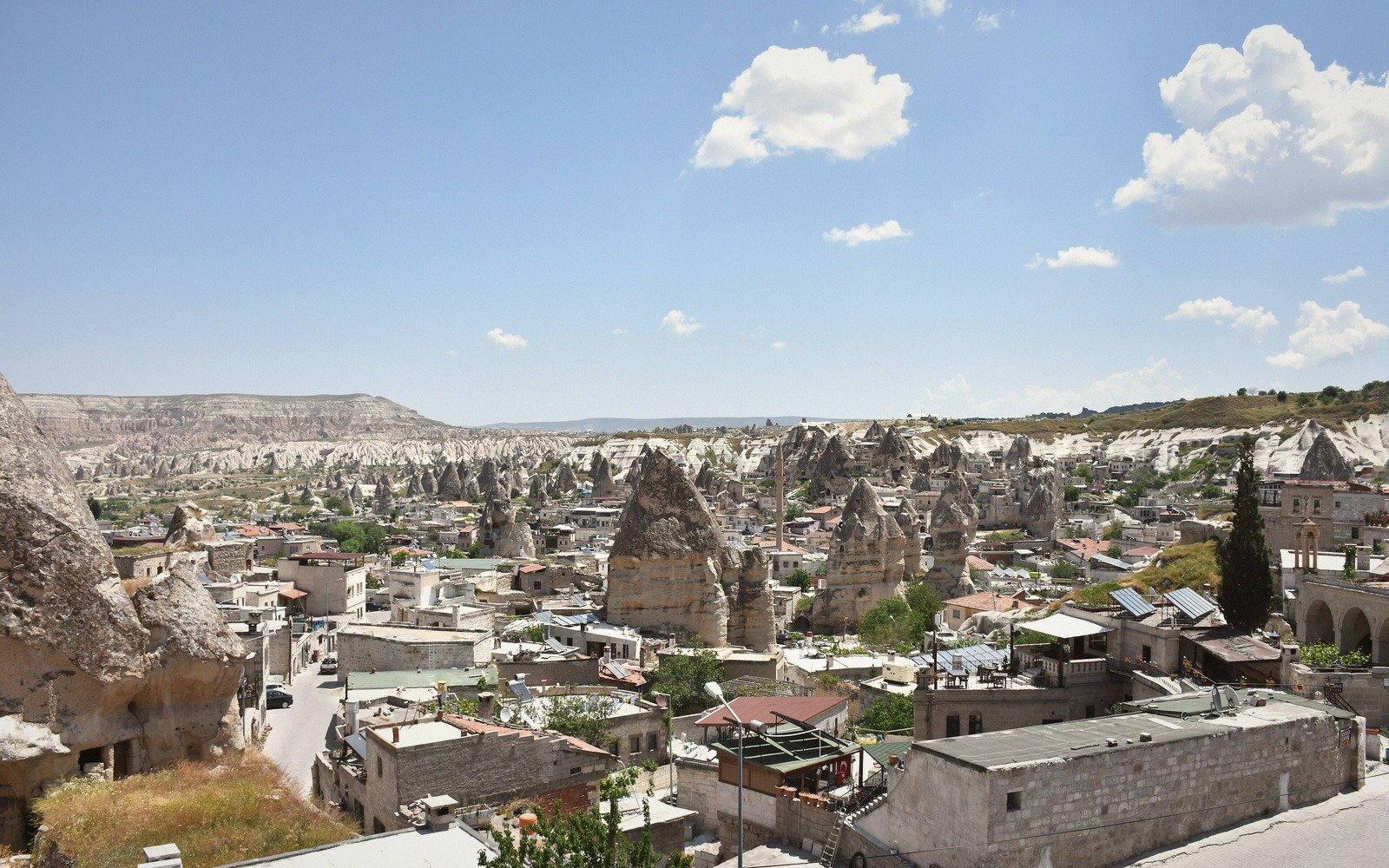
Erosion did not happen evenly. It began at the surface, where rain, frost, and wind attacked the exposed tuff, wearing it down and carrying it away. Anywhere a harder cap of basalt sat atop the tuff, that cap sheltered the material directly below it while everything around it eroded freely. The result is the fairy chimney — the peri bacası in Turkish — a column or cone of soft tuff wearing a darker basalt hat like a mismatched crown. The softer column survives only because the cap above it intercepts the rain and disperses it outward; the cap itself, being harder, resists the same forces. Where no cap existed, the tuff was eaten away uniformly, producing the smooth, undulating valleys between the formations. Where a cap did exist, the chimney stood. Where the cap eventually falls — as it always does, through the cracking and weighting and frost action of centuries — the column below is exposed to direct erosion and begins to shrink rapidly.
This is a landscape still in motion. The chimneys at Göreme, at Ürgüp, at Zelve, are not finished forms but snapshots of an ongoing process. A cap that holds for another few centuries produces a taller, more slender chimney; one that falls tomorrow produces a stump and then, in time, nothing.
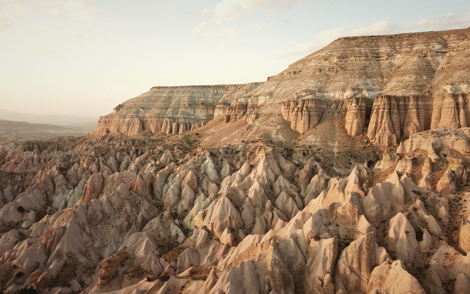
The valleys themselves tell the same story in broader strokes. The Kızılçukur — the Red Valley — gets its colour from iron oxides in the tuff, oxidised over long exposure. The Ihlara Valley is something more dramatic: a canyon carved by the Melendiz River cutting down through the plateau, exposing walls of tuff dozens of metres high, lined now with rock-cut chapels that are the direct beneficiary of how easily this stone yields to a chisel. Across the region, the same principle applies at every scale: soft material, differential resistance, persistent water and wind, and time measured in geological rather than human units.
Once you know it, the landscape stops looking magical and starts looking inevitable.
By the numbers
roughly 30 million years agoapproximate start
hundreds of metresdepth of tuff
roughly 80 metres below grounddepth of Derinkuyu underground city
1,000–1,200 metres above sea levelaltitude of the Cappadocian plateau
sixth to thirteenth centuriesmain period
03A Stone That Invited Habitation
Tuff's very softness, which made it so vulnerable to erosion, made it equally yielding to human effort. Cut into with basic tools, it hollows readily, holds its shape once the surface skin hardens on exposure to air, and provides excellent thermal insulation. The Cappadocian rock-cut tradition is ancient: people were excavating living spaces, storage rooms, and eventually churches and monasteries into the valley walls from at least the early Christian era, though the full flowering of the region's troglodyte architecture came during the Byzantine period, roughly from the sixth century onward and intensifying through the ninth to thirteenth centuries.
The Göreme Open-Air Museum concentrates the most visited examples in one valley: a cluster of monastery complexes in which entire programmes of Byzantine fresco painting survive inside chambers cut from the tuff. The Dark Church — Karanlık Kilise — is named for the small aperture of its single window, which accidentally preserved its pigments from the light that bleaches others. The Apple Church, the Snake Church, the Buckle Church: each is a theological and artistic programme compressed into a sculpted cave, with barrel vaults and domes painted to mimic the structural forms of built churches, translated faithfully into a medium that needed no arches to stand up.
The underground cities deepen the story. Derinkuyu and Kaymaklı are the two most thoroughly explored, both reaching many storeys below the surface, with ventilation shafts, stables, winepresses, wells, churches, and rolling millstone doors designed to seal corridors against intruders. Who excavated these and in what precise sequence remains debated; they were certainly in use during Byzantine times and may have earlier origins. Derinkuyu descends to roughly eighty metres below ground. Walking it is a lesson in how seriously people took the insulating and concealing properties of Cappadocian rock.
The pigeon houses cut into the cliff faces throughout the region belong to the same practical tradition, though their purpose was agricultural rather than residential: the birds were kept for their droppings, which are a particularly effective fertiliser in a region where the volcanic soil is mineral-rich but thin. The geometric patterns painted around the openings to attract birds are some of the most quietly beautiful decoration in Cappadocia, made not for human appreciation but for pigeons, and discovered almost accidentally by anyone who looks up.
04The Plateau and Its Climate
Cappadocia sits at roughly 1,000 to 1,200 metres above sea level, which shapes its character as much as its geology. The winters are genuinely cold, the summers hot and dry, the spring and autumn brief but vivid. The plateau's semi-arid character explains why the erosion here has been so extreme: there is not enough vegetation cover to bind the tuff surface and slow the loss of material, but there is enough occasional rainfall and freeze-thaw cycling to do real erosive work over time. A landscape with more rainfall would have developed a forest cover that would have stabilised it; a landscape with less would have eroded more slowly. Cappadocia sits in an erosion sweet spot, which is either lucky or unlucky depending on whether you are the rock.
The same plateau climate produces the wine for which the region has been known since antiquity. The volcanic soils, combined with the diurnal temperature swings of a high-altitude semi-arid landscape, suit viticulture. Strabo, writing in the first century BCE, noted wine production in the region. The variety Emir — a white grape indigenous to Cappadocia — is still grown here, producing a pale, crisp wine that reflects the mineral character of the ground it comes from. The vines are trained low, in a traditional goblet form, partly to capture warmth from the soil and partly to survive the wind that has been reshaping everything else here for geological ages.
05Reading the Landscape
Seen from the air, or from the rim of a valley at dusk, Cappadocia resolves into a comprehensible system. The higher plateau — largely intact, flat, used for agriculture — represents what the whole landscape once looked like before erosion began to dissect it. The valleys are where the dissection is most advanced: river channels and gullies have lowered the surface, leaving the intervening ridges as peninsulas of the original plateau, and the chimneys as the most isolated survivors of all, ringed by erosion on every side, preserved only by their caps.
Every element is reading the same text in a different chapter. The plateau is the beginning; the valley walls with their frescoed churches are the middle; the free-standing chimneys are deep in the later pages; and the worn stumps and rounded hills beyond them, where the basalt caps have long since gone, are closer to the end. The story is not finished — it cannot be finished while water runs and frost cracks stone — but Cappadocia's particular genius is that all the chapters are visible at once, laid out across a landscape that takes the full measure of time and makes it briefly, extraordinarily legible.
To walk from the plateau edge down into a Göreme valley is to walk forward through geological time rather than backward through it: the oldest understanding is at the rim, where the rock is still nearly whole, and the most eroded, most worked, most human-inhabited forms are at the bottom, where the soft stone has been worn and hollowed and painted and lived in and is slowly, inexorably, continuing to disappear.
How it went, in order
A chronology, as the sources give it.
~30 million years agovolcanic eruptions begin depositing tuff across the Anatolian plateau
6th–13th century CEmain phase of Byzantine rock-cut churches, monasteries and frescoes in Göreme valleys
1st century BCEStrabo records wine production in the Cappadocia region
map-slot
Locator for Cappadocia (Göreme) — real geometry, true coordinates.
Cappadocia (Göreme) on the map of pinned sites. Drawn from the supplied Natural Earth geometry at true coordinates — nothing here is sketched. Every guide carries a pin and a layer, so a place can be found by where it is or by when it is.
Named in this guide
Erciyes Dağı
Extinct stratovolcano east of Kayseri; one of two main volcanic sources of Cappadocian tuff.
Hasan Dağı
Extinct stratovolcano; western volcanic source for Cappadocian tuff deposits.
Göreme Open-Air Museum
Valley complex of Byzantine cave-church monasteries with surviving frescoes.
Karanlık Kilise (Dark Church)
Rock-cut church at Göreme; well-preserved frescoes owing to minimal light exposure.
Derinkuyu
Multi-storey underground city descending roughly 80 metres into the tuff.
Kaymaklı
Large excavated underground city; among the most thoroughly explored in Cappadocia.
Ihlara Valley
River canyon cut by the Melendiz River; noted for riverside rock-cut chapels.
Kızılçukur (Red Valley)
Iron-oxide-coloured tuff valley in the Göreme area.
Strabo
Greek geographer, 1st century BCE, who recorded viticulture in Cappadocia.
Words used above
tuff
compacted volcanic ash and pumice compressed into soft sedimentary rock
peri bacası
Turkish for fairy chimney; a tuff column capped by harder volcanic rock
pyroclastic
relating to rock fragments and ash ejected by a volcanic eruption
troglodyte
cave-dwelling; here used for rock-cut domestic and religious architecture