An independent guide to the culture, places and craft of Turkey
Landscapes
The Lycian Coast, Between Two Ruins
Rock tombs carved into cliffs above a sea that has not yet filled in the gaps.
By the ReaderLandscapes3 min readGreek
01What the Tombs Are Doing Up There
The southwestern edge of Turkey bends and folds in a way that resists easy travel. The Teke Peninsula, which ancient geographers called Lycia, is a wedge of limestone mountains driven into the Mediterranean, its coastline broken into coves, headlands and drowned river mouths so deep they read on maps as fjords. For most of recorded history, the towns here were easier to reach by sea than by land. The roads came late. In places, they still feel provisional.
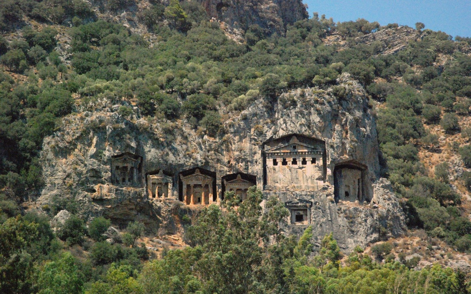
That geography shaped a civilisation that left its most dramatic mark not in temples or agoras — though those exist too — but in the cliffs. The Lycians carved their tombs into rock faces from roughly the fifth century BCE onward, placing the dead high above the living in chamber-tombs and pillar-tombs that imitated the timber facades of wooden houses, translated into stone. The effect, on a coastline where a cliff might rise directly from the water, is peculiar and quietly unsettling: the shore and the afterlife occupy the same vertical plane, separated by a few metres of limestone.
The most legible group sits above the harbour at Kaş, and another lines the waterway at Kaunos, near Dalyan, where the tombs gaze out across a delta that is still slowly silting. But the finest concentration — and the most theatrical — is at Myra, a few kilometres inland from the coast at Demre. Here, two registers of tombs are stacked in the cliff face, each carved with the same decorative woodworking vocabulary: beam-ends, gabled pediments, painted plaster surviving in patches of ochre and red. You reach them on foot, by a path that climbs through scrub oak. From below, with the cliff rising and the necropolis arrayed across it, the silence has a specific quality — not abandoned, exactly, but uninhabited.
They are not monuments in the triumphalist sense — no inscription announces an empire.
By the numbers
5th century BCEapproximate period Lycian
540 kmapproximate length
02What the Rest of the Coastline Does
The Lycian coast is long enough, and awkward enough, that no single image captures it. The western end, around Fethiye and the Ölüdeniz lagoon, has been absorbed into tourism for decades. The eastern end, where the Taurus Mountains push the road into tunnels and the towns are fishing villages with one hotel apiece, is a different proposition. Between those poles lies the middle stretch — Kaş, Kalkan, the Kekova Roads — where the infrastructure exists but the coastline still asserts itself.
Kekova is where the drowned city makes the case most plainly. A small island, largely off-limits to landing, has submerged ruins along its northern shore: walls descending into the sea, steps cut into rock and now running out beneath the water, the outlines of harbour installations visible at low tide and low sun. The submergence happened gradually, through seismic shifts rather than a single event, and the effect is less dramatic than the idea of it. You look down through clear water at masonry and think about time moving at a pace that ignores urgency. Across the narrow channel, the village of Kaleköy clusters around a medieval castle on a Lycian acropolis — the standard Lycian arrangement, in which each generation builds on what the last could not be bothered to demolish.
The Lycian Way, a long-distance walking route marked and mapped from Fethiye to Antalya, threads through this landscape at the pace it deserves. The trail crosses pine forest and open limestone pavement, drops to coves with no road access, and passes through the ruins of perhaps a dozen ancient settlements that receive a handful of visitors between them. Sidyma. Pınara. Tlos. These are not the grand sites — they lack the restored colonnades and visitor facilities of Ephesus — but their incompleteness is exactly the point. A theatre with its seating half-collapsed back into the hillside, a tomb with a fig tree growing out of its lintel: the ruins are still being absorbed by the landscape rather than extracted from it.
The rock tombs are the most concentrated expression of what this coastline does to a particular kind of attention. They are not monuments in the triumphalist sense — no inscription announces an empire. They are domestic architecture at the scale of permanence, a culture insisting that the form of the house should outlast the house itself, and choosing the highest, hardest wall available to make that argument.
map-slot
Locator for Lycian coast (Kaş) — real geometry, true coordinates.
Lycian coast (Kaş) on the map of pinned sites. Drawn from the supplied Natural Earth geometry at true coordinates — nothing here is sketched. Every guide carries a pin and a layer, so a place can be found by where it is or by when it is.
Named in this guide
Lycia
Ancient region of southwestern Anatolia, now roughly Antalya and Muğla provinces.
Myra
Ancient Lycian city; rock-tomb necropolis near modern Demre.
Kaunos
Lycian–Carian city near Dalyan; cliff tombs overlook the delta.
Kekova
Small island with submerged ancient ruins along its northern shore.
Kaleköy
Village on a Lycian acropolis above Kekova Roads, with a medieval castle.
Pınara, Sidyma, Tlos
Secondary Lycian city-sites on or near the Lycian Way.
Lycian Way
Marked long-distance walking route, Fethiye to Antalya.
Words used above
necropolis
city of the dead; a burial ground or collection of tombs
acropolis
fortified high point of an ancient city, typically its oldest nucleus
pillar-tomb
Lycian tomb type: a burial chamber raised on a single tall stone pillar
pediment
triangular gable end above a classical facade, here carved into cliff faces