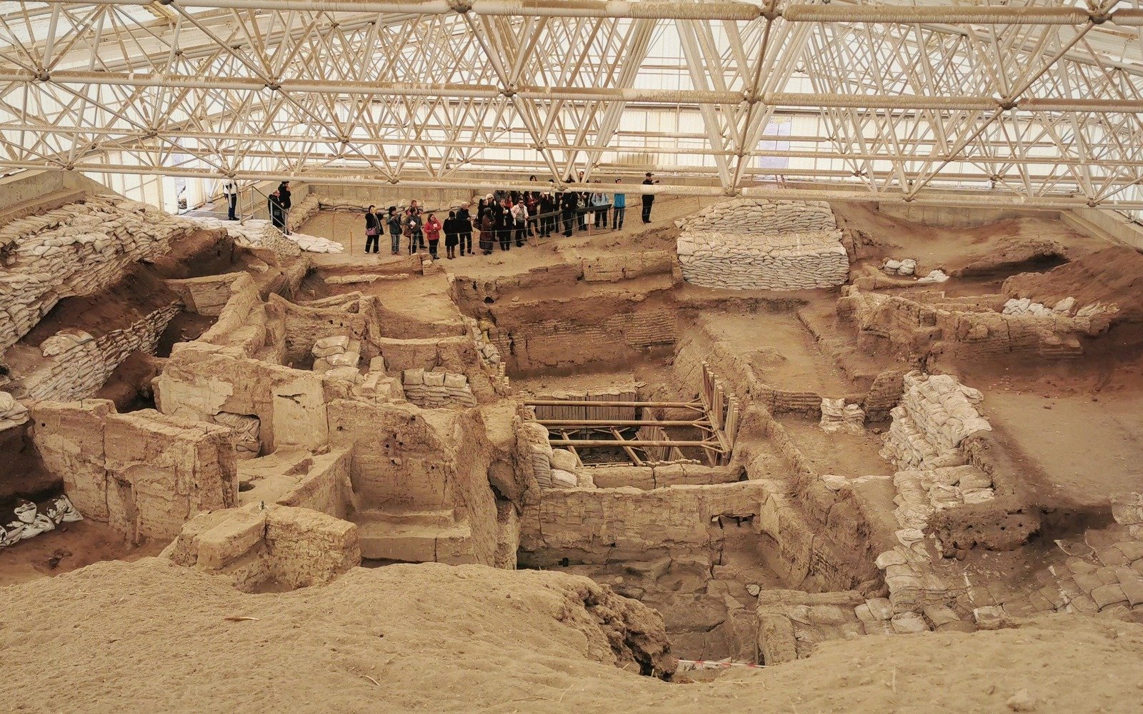
A Neolithic settlement entered from the roof — and what that strange architecture reveals about how nine thousand people organised a life together.
01A Town Without a Ground Floor
Çatalhöyük sits on the Konya Plain in central Anatolia, a low mound rising from flat agricultural land about fifty kilometres southeast of the city of Konya. From a distance it looks unremarkable — a tell, an accumulated hill of human occupation. Step closer, and the archaeology becomes strange enough to rearrange your assumptions about what a town has to be.
The site was occupied for roughly twelve centuries, from around 7100 BCE to around 6000 BCE, and at its peak it held somewhere between five thousand and nine thousand people — a genuinely large community for the Neolithic world. What those people built, and the way they built it, is unlike almost any settlement that came before or after. Çatalhöyük had no streets. It had no lanes, no alleyways, no open passages threading between buildings. The houses were pressed against one another in a solid mass, sharing walls, with no ground-level gaps between them at all. To move through the settlement, you climbed up to the roofline and walked across the top of the city.
Entry was through a hole in the roof, down a wooden ladder into a main room below. That ladder-hole also served as a chimney — the hearth sat directly beneath it, so smoke rose and exited through the same opening that people used to descend. Every household, in other words, entered its own home the way we might enter a cellar. Archaeologists have found the remnants of these ladders, and the compacted wear patterns around the roof openings confirm they were used constantly and by everyone.
02What the Architecture Says
A town entered from the roof is not merely a curiosity of engineering. It tells you something about the social logic of the place.
Without streets, there is no public ground-level circulation. There is no place where people must pass one another, no market square that everyone crosses, no bottleneck where hierarchy might announce itself through placement or access. What Çatalhöyük had instead was a roofscape — a shared external surface that was simultaneously the ceiling of private space and the open terrain of daily movement. The roof was where people worked, cooked outdoors, dumped refuse, and presumably talked to neighbours who were, literally, one wall away.
Excavations led over recent decades by teams from the University of Cambridge and later a larger international consortium have added layer after layer to this picture. Inside the houses, the archaeology is remarkably consistent. Each main room followed a similar arrangement: a hearth and oven set into the floor on the south side, sleeping and working platforms to the north and east, the ladder descending from the south end of the ceiling. This standardisation is so pronounced that researchers have debated whether it reflects shared cosmological orientation — a sense that the house itself was a structured cosmos — or simply an efficient solution that every household independently converged upon.
The dead were buried under the floors, beneath the very platforms where the living slept and worked. Skulls were sometimes retrieved after burial and replastered, given new painted faces, and circulated among households in ways that suggest the dead remained active presences in daily life rather than beings consigned to a separate realm. The boundary between the domestic and the ancestral was, in a literal sense, underfoot.
Wall paintings at Çatalhöyük include geometric patterns, hunting scenes, and images of large bovines and vultures. Some panels were repeatedly replastered and repainted over generations — the wall surface itself becoming a kind of palimpsest, accumulating imagery across decades. One famous composition appears to show a town with a peak erupting behind it, which some researchers have interpreted as a map of Çatalhöyük itself with a nearby volcano, though that reading remains contested.
It had no lanes, no alleyways, no open passages threading between buildings.